Goldfields Getaway
24 June, 2021
Tracing the Loddon River by John Moir
The Loddon River – an inland river of the north-central catchment, part of the Murray-Darling basin – is located in the Central Highlands and Loddon Mallee regions in the state of Victoria. The Loddon River starts its journey on the northern...

In this winter edition of the Goldfields Getaway magazine, I want to take you on a river tracking tour, up-stream from Bridgewater, following the Loddon River, so you can see how great this river is for the Central Goldfields areas. Please note that some of the driving will be on dirt roads.
The Loddon River – an inland river of the north-central catchment, part of the Murray-Darling basin – is located in the Central Highlands and Loddon Mallee regions in the state of Victoria. The Loddon River starts its journey on the northern slopes of the Great Dividing Range east of Daylesford and flows north into the Little Murray River near Swan Hill.
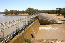
Bridgewater has a weir that is used for water for the local area. It also provides a water-skiing area as well as good fishing. A visit to Bridgewater allows you to try a meal at the local pub and see some of the shops including a couple of art/collectable shops.
Bridgewater has large industry in wine growing, flour mill and tomato growing. There is also a ‘farm’ with mysterious dishes to trap solar energy located out on the Bridgewater to Maldon Rd. However, we are going to go north from the pub over the bridge and turn left down the road to Dunolly.
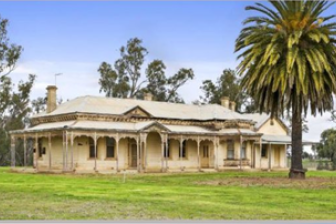
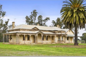
Around four kilometres from the Calder Highway (bridge) you need to turn left down the road to Newbridge. Just over two kilometres is the old original Memsie Station homestead. It is believed it was first built around 1840 for the Catto Family but research has yet to confirm this.
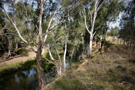
Continue on till you get to a camping area on your left and that is again the Loddon River. In from here to the right and just short of a kilometre is a very large hole in the river that is approximately 25 metres deep. It was possibly created in the bygone ages before man by a waterfall. In it lives a great protected cod. This same section of river boasts some unusual things such as a small billabong, a small gorge and a platypus colony.
There is still a cellar underground near the camping area that was part of one of the breweries located on the section between the camping ground and Catto Lane. The original homestead is down Catto Lane.
When you come to the highway turn left into the town. A visit to the pub is well worthwhile as there may still be photos of past fishing exploits. Do not cross the bridge but head south with the river on your left and in around four kilometres you will pass by the area of Poseidon where gold was found around 1850. There is still a working mine in the area today.
Travel on down to a cross roads and take a left into Laanecoorie. Go over the bridge and park. Walk down into the camping ground and read the signage on the area.
If you take the road opposite that runs with the river on your right it takes you up to the weir gate area. Then continue off to your left. If you take that road back to the main road you will need to negotiate a turn to the right. This will take you back to Eddington where you could stop at the area before crossing the bridge.
Down the bank (if you are able) and walk down to the left and there you will find the place where the Tullaroop Creek enters the Loddon. (I understand it may have been called Deep Creek in the past).
Back on the road again and carefully find a place to turn back and take the first turn right and then right again down the road to Baringhup. In this road, approximately three kilometres on your right, is an island in the river and it may well form an oxbow lake in time. Continue on enjoying the scenery and if you have keen eye-sight you may see a vineyard to your right in the distance (it is actually on the creek). Cross over the next intersection and on into Baringhup.
You have a choice here where you either turn left and then right to go see the wall and the open water or you turn across the bridge (over the Loddon River) and then stop for a look around and even take a walk up to the wall. However, when you are ready continue on taking the first road to the left and in around three kilometres turn left and follow the road around Cairn Curran Reservoir to the Joyce’s Creek cross-over and main highway. Here turn left over the bridge that crosses the backwater and creek entrance to the Cairn. Head off down to Newstead for a coffee.
From this point it is not easy to follow the river and it next appears in Guilford as a small stream and again you see it as a trickle just a few hundred metres toward Daylesford from the Lyonville Hotel on the Trentham to Daylesford Road.
It actually starts in a small lake and flows north through the Wombat State Forrest and will pass near Glenlyon Store where you can visit the Loddon Valley Scenic park located nearby (ask at the store).
Now that will be different for the followers of my stories. Let me know how you get on.


